Since my 3 February posting “Food for thought on the cause of the Wye River–Separation Creek Christmas Day bushfire devastation” (click here), I’ve been provided with information on what I referred to as a time-lapse view of the fire area that was produced by Ripe Intelligence (click here)
The origin of the information in the video
The information came from the Vic Emergency web site (click here). At the date of this posting a plot of the fire area may still be available as part of the advice continuing to be posted on that fire.
Timing of the information
The fire spread sequence timings referred to as “time–lapse views” are shortly after the data to prepare the video was progressively taken up and posted by Ripe Intelligence. The perimeter data on the Vic Emergency web site does not include an observed date/time.
The time it appears on the Vic Emergency web site can be influenced by how busy the people responsible for the mapping are e.g. they may be dealing with more than one fire and mapping may be slow coming from the field.
Information on the spread of the Wye River–Separation Creek fire would have been critical to timely warnings to the community on Christmas Day. Consequently, I’m confident that times of the fire spreading shown in the video would have been close to real-time.
What the video shows
I’m informed that the video (click here) is published as an “impact area” rather than a fire perimeter given the limitations in the collection process, accuracy and intended use of the data. And, that generally, unburnt area is not depicted by agencies when initially publishing this type of information. It is added as detailed data becomes available and time allows.
Data behind the video
In my pursuit of the truth concerning where the Wye River–Separation Creek fire originated and the true meaning of “inaccessible” Ripe Intelligence provided additional data on the spread of this fire.
Below are the “time lapse” sequences overlaid on Google Earth. Here, my objective is to better show the fire caused by the lightning strike initially relatively small and clearly on the southern side of Jamieson Creek.
Comparing the terrain with the extract from Vicmap Topographic Map T7620-1-1-S (below), which is generally centred on Jamieson Creek in the area shown in the Google Earth extracts covering the vicinity of the lightning strike, I’m not convinced that any of that area is inaccessible to well-equipped, well trained, experienced and determined firefighters.
The arrow on the map points into the area more broadly shown in the video at 6:08 PM on 21 December.

The first three photos from Google Earth that match the sequences in the EmergencyAus video show the fire as not having crossed to the north side of Jamieson Creek:
6:08 PM 21 December 2015

12:44 PM 25 December 2015

4:04 PM 25 December 2015

4:38 PM 25 December 2015
Western end of the fire has started to move northwards.

8:38 PM 25 December 2015
Fire is on the steep upslope between Jamieson Creek and Cumberland Track.

3:48 AM 26 December 2015
Fire developing north of Jamieson Creek.

1:24 PM 26 December 2015
Fire continuing to develop north of Jamieson Creek. Could this have led to "lookout Lorne, here I come"?

With the benefit of more information
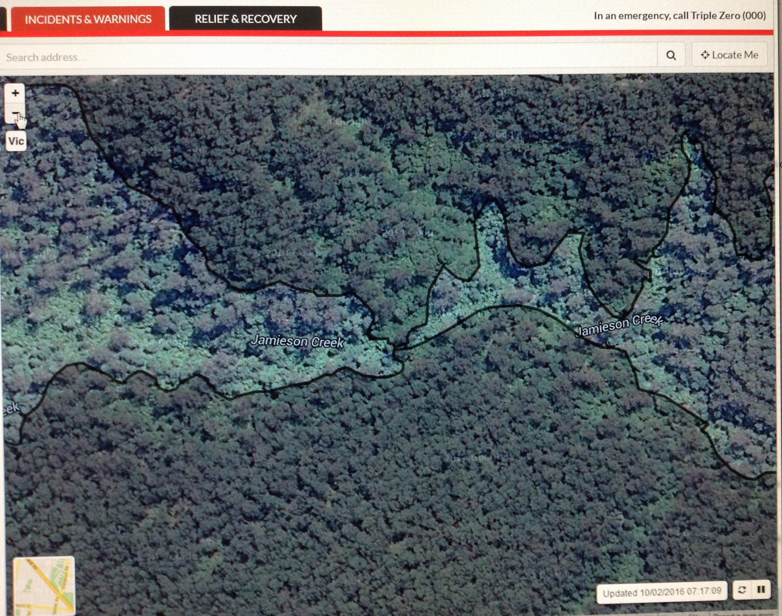
The following photos are from the Vic Emergency website on 10 February 2016 as an example of the agencies having had time to develop a detailed map of the total fire perimeter.
They are worth close examination to see the linkage between the fire areas north and south of Jamieson Creek. Having studied the information provided above I'm convinced the lightning strike was south of Jamieson Creek and in accessible terrain. Local knowledge suggests that the vegetation along the bottom of the gully would have been sufficiently damp to prevent the fire spreading to the north during the relatively mild days following the lightning strike.
It also seems reasonable to suggest that the northern control line for the fuel burnout was the damp fuel along the Jamieson Creek.
How then did the fire cross to the northern side of Jamieson Creek? Probably "spotting activity", possibly the approaching wind change starting to have an effect high up on the convection column, as Tolhurst opined on in work he did for the 2009 Victorian Bushfires Royal Commission: Report on the Physical Nature of the Victorian Fires occurring on 7th February 2009, final paragraph on page 6 (click here).


Where to from here?
A range of factors involved in initially controlling — or failing to control — the lightning strike to prevent the fire area growing to the extent where it broke out Christmas Day needs serious in-depth investigation.
And of course a key question:
Was the fire considered inaccessible if it could not be encircled by a bulldozer and tankers?

No comments:
Post a Comment